
As the Israeli military continues its operation in Gaza’s southern region of Khan Younis, new satellite imagery reveals how far their ground forces may have reached.
At least three areas just north of the city show groups of military vehicles, while visible tracks can also be seen 1.2 miles (2km) from one of the city’s main hospitals in an image taken on Wednesday.
Due to restricted access into Gaza, there has been limited independent visual evidence showing Israel’s ground operation.
In early December, Israel said it expanded its air and ground operation in the southern part of the Gaza Strip, the army now claims it has been fighting in the centre of Khan Younis.
Armoured vehicles

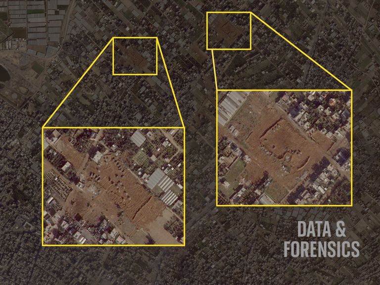
Satellite image shows three areas containing Israeli military vehicles north of Khan Younis city. Pic: Planet Labs PBC
At least 10 vehicles can be seen in the yellow box on the far right of the image above in Kaf Elabadla which is around three-and-a-half kilometres north of Khan Younis city.
It’s located just west of the Salah al Din road – one of the main roads running through the Gaza Strip which many Palestinians used to evacuate the north.
The image was taken at 7.33am UTC by Planet Labs PBC. The two boxes below show a closer view of two of the areas.
Two areas where sand banks and vehicles are seen. Pic: Planet Labs PBC
The area on the right shows more vehicles by a sand bank just metres away from where a video IDF posted on 6 December was taken.
The army said the video shows the IDFs special forces division, Division 98, “fighting for the first time” in what they describe as “the heart of Khan Younis”.
The video was filmed almost 1.9 miles (3km) from the centre of the city.
The location of the area on the left in the image above is located about 1.5 miles (2.4km) northeast of Khan Younis’s Nasser Hospital.
Sky military analyst Sean Bell said the areas where military vehicles have been spotted are likely to be “forward operating bases for Israeli troops” – with the sand banks allowing a degree of protection.
Previous satellite imagery taken on 3 December showed dozens of military vehicles further north closer to Deir al Balah.
Tracks seen on ground

Pic: Planet Labs PBC
Moving closer to the centre of Khan Younis city, vehicle tracks are also seen alongside circular craters in the ground. Sky News is unable to verify what vehicles created these tracks.
The IDFs operation in Khan Younis, the home town of Hamas leader Yehya Sinwar, marks the expansion of their offensive in Gaza.
The move has shrunk the area where Palestinians can seek safety and halted the distribution of vital aid across most of the territory. Many Palestinians had fled south following bombardment in northern Gaza and Gaza City and warnings from the Israeli army.
The assault on the south threatens further mass displacement within the besieged coastal enclave, where the UN says some 1.87 million people – more than 80% of the population – have already fled their homes.
The Data and Forensics team is a multi-skilled unit dedicated to providing transparent journalism from Sky News. We gather, analyse and visualise data to tell data-driven stories. We combine traditional reporting skills with advanced analysis of satellite images, social media and other open source information. Through multimedia storytelling we aim to better explain the world while also showing how our journalism is done.